Citizen Participation in Regional Master Plans: Watch London and Bangalore

I think I speak for all my fellow planners that no plan ever created has ever had “enough” public participation. Inevitably, no matter how broad (or narrow) the planning outreach and engagement process, there will be someone or some groups who will not feel adequately consulted or included. I have been at the helm of planning processes and public forums where this sentiment has been publicly hurled, deservedly or not; surely, a terrible feeling. It often feels like a professional hazard of the job.

But knowing this, there are so many ways that planners around the world attempt to address the issue of inadequate public participation, not only to save oneself from public outcry but more importantly to ensure a collaborative plan that will more assuredly be implemented to meet constituents needs.

So we have a moment when two draft regional master plans have been released by two megacities of roughly the same size, on roughly the same day, with two completely different approaches to citizen feedback.

Bangalore (pop. ~10 million in 2017): Revised Master Plan for Bengaluru 2031 was released to the public on November 24, 2017 for a 60-day comment period. The sections of the plan are available online, however, the means of commenting are through a physical form that the potential commenter must download and mail back to the planning body, the Bangalore Development Authority (BDA). No official public consultations have been advertised by the BDA but several civic organizations have begun to help the public strategize on how to respond and comment effectively. This feedback strategy clearly puts the burden on the public to self-organize and respond in a way that will be “heard” by the planning authority.

London (pop. ~9 million in 2017): New London Plan was released to the public on November 29, 2017 for a 90-day comment period. In addition to sending comments by mail, the public has the ability to provide comments directly in the relevant section of the plan using smart-document technology and collate comments for future edits. On the day that the plan was released, the Planning section of the Office of the Mayor also announced 11 public consultation events between December 1 and February 5, 2018. By law, the comments received for the London Plan will be examined by an Independent Planning Inspector.

Surely, Bangalore and London are very different cities with different planning traditions and urban governance structures. I have no doubt that both processes will hear from constituents who say they were not informed of the plan. But the use of technology in London, which could easily have been adopted in Bangalore–India’s tech capital, and the convening of the public by the planning authority itself seems like a missed opportunity.

Planners everywhere can watch this master planning processes unfold and hopefully learn what they can do in their own cities.

Bangalore’s Ambivalence Towards Its Master Plan

Well, as luck would have it, the Bangalore Development Authority (BDA) released the draft of the Regional Master Plan 2031 (RMP 2031) just one week after I left from my 4-month fellowship. I had spent several hours at the BDA waiting to speak with planning officials, and up until the last week, there was no indication of when the draft plan would be released to the public. On November 24, 2017, the BDA issued a public notice (where?) that the plan was available for public comment for 60 days.

The process for planning RMP 2031 began more than 2 years ago, when the BDA  outsourced the preparation of the plan to a Netherlands-based company Royal Haskoning DHV. Much of the work was largely to collect critical GIS, remote sensing and survey data that would be used as inputs to the plan. In January 2017, the BDA had a series of 8 public consultations to review preliminary visions or scenarios that would guide the plan. As of today (Nov 27), there are no public consultations scheduled, but various citizen groups are starting to encourage their networks to participate during the comment period.

I spent my time in Bangalore interviewing stakeholders from various domains of civil society on how they viewed the the city’s master plan. While there is overwhelming desire for a long-term comprehensive plan to better manage the growing city, the process for preparing RMP 2031 has been fraught with contestation. So during these next 60 days, the questions revolve around:

  1. How organized are citizen’s groups towards building consensus to formulate their comments into actionable revisions that the BDA will not easily dismiss?
  2. How will the master plan impact each ward during implementation? How do wards uniquely need to be prepared?
  3. In general, how will the plan be implemented? And how will Bangalore residents be able to track progress?

Since the data collected for my research through semi-structure interviews between September and November 2017  provides extremely recent opinions on the master plan, I thought it would be of value to let the voices of the interviewees be available for everyone during this 60-day comment period. I hope it’s useful for all the people I met who are so passionate about their city.

Bangaloreans Want a Master Plan

The most evident sentiment from multi-sector stakeholders in Bangalore was that people wanted their city to be better planned.

You can say growth is a problem or a blessing in disguise. But it’s the way it is managed that is the problem. We are not building the city, it’s like it’s being built on its own. And things are not coordinated. Like land development is not connected to transportation planning. Unless you have control over who is building where and how, you will not solve any problem in this city.” (Community-Based Organization)

“They are all fire-fighting all the time. It makes me tired to see all the Whatsapp messages all the time. It’s sad that everyone is struggling on a daily basis to get the potholes filled, the garbage guy to collect garbage. It’s not just urban planning or the delivery of urban services, there are violations of everything. Everyone is just trouble-shooting and fire-fighting all the time, we don’t have the time and space to think about what this place needs in the future.” (Local Planner)

“The [master] plan could be relevant, but not the way it’s going around. It has to be relevant. It has to be done in a better way.” (Non-Governmental Organization)

…But They Are Not Sure RMP 2031 is Their Plan

This master plan for Bangalore is mire with legal ambiguities. The State of Karnataka Town and Country Planning Act, enacted in 1961, gave the authority to the Bangalore Development Corporation (established in 1976) to plan for the larger area. The BDA has created previous master plans from 1985, 1995 and 2015. However, the 74th Amendment of the Indian Constitution, adopted in 1992, called for the establishment of a Metropolitan Planning Committee (MPC) to plan for all metropolitan areas in the country and required more local participation in the planning process particularly through ward committees. The MPC for Bangalore was only constituted in 2014, after the RMP 2031 was started per the State Planning Act, and in the past 3 years has only met formally twice. So the BDA is technically mandated to do a plan for Bangalore, and the MPC may or may not be in any capacity to even review the plan, let alone conduct a planning process itself.

“The State has legally said that …that the BDA should do the plan, but it goes against the spirit of the 74th Amendment. Therefore, we have to have a lot of negotiation and conversation with the government to change these things.” (Consultant)

“Complying with the letter of the law is quite easy without ever coming close to the spirit of the law. They’ll make up the argument that is convenient to the proposition they are pushing forward. There are lawyers who will acquiesce to this, there are planners who will acquiesce to the master planning process.” (Citizen Activist)

There is also a lack of legitimacy regarding who is involved and how the process is slated to proceed. 

“Who are they [BDA] to create a plan for my city?” (Citizen Activist)

“It might be the MPC that acts as the review committee. But there is a conflict of interest. The plan has been prepared by the BDA which is headed by the Chief Minister of KN and cannot be reviewed by the MPC that is also headed by the CM.” (Consultant)

Even though planning for RMP 2031 has been going on for several years, the predominantly closed process has left many people wondering who the plan is really for. 

“It’s basically a supply-driven planning mechanism. Planning authorities supply what they think is good for the city. This conception of what they think is good for the city is not informed by any of the other governmental agencies nor the private sector agencies nor any of the other non-state actors in a formal institutionalized manner.” (Local Planner)

“We have participated in the MP consultations that have happened in different zones. …We spoke, we were one of many stakeholders. We have given our submissions and hopefully they’ll get acted upon. The problem with the MP process is that none of the feedback given are formally documented and closed.” (Non-Governmental Organization)

Finally, the style of planning appears to be rather technocratic in the sense that the government officials and consultants are employing sophisticated data analysis and best practices. That implies that the voices of citizens must “compete” and rise to the level of expertise to be on equal footing. 

Ultimate it is based on the strength of the development authority. The governmental agency will try to accommodate the interests of the citizens as much as possible. So if I get 20,000 objections to my draft master plan, i can only accommodate a portion of them. These are all genuine demands. Many times what happens is planning is not done by actually visiting those areas. Somebody sitting at the table will decide something.” (Government Official)

“Now i think there will be a lot of noise when we open up the plan. It will influence some of the decisions in the plan. I feel that it can certainly if it is channelized properly. It is voiced properly, framed properly, it can definitely have an impact on the plan. But if it is just noise, just anecdotal noise, where there is no evidence to back up the noise, then it won’t have an impact.” (Consultant)

Weaving Together Bangalore’s Local Citizen Engagement Efforts

Presentation at Citizens Agenda for Bengaluru and Citizens for Bengaluru — Citizens Centric Talk Series 

Small Area Collaborative Planning for a Sustainable Bangalore

I came to Bangalore on this Fulbright-Nehru fellowship to reflect on a fundamental question applicable to any city–How do decisions get made in urban areas? So many people are involved in urban governance, as I’ve written about in this previous blog post.

While here in Bangalore, I used mostly qualitative methods (semi-structured interviews, archival research and participant observation) to learn about how actors in various domains of urban life work together to achieve a more sustainable city. As someone who has studied master planning processes around the world, I focused on the fact that Bangalore is going through a master planning process right now to see what direction the city is headed in for 2031. The following proposal attempts to weave together the great works that citizens in Bangalore are engaged in to ensure collective impact of their otherwise decentralized efforts.

Background

While the 74th amendment to the Indian constitution passed nearly a quarter of a century ago aimed to herald greater recognition and autonomy to the metropolitan regions of India, its implementation has been significantly hampered by the lack of political will to allow for the devolution of power on the one hand and due to the increasingly complex issues that impact urban areas on the other. In the State of Karnataka, the current status quo is further compounded by legal ambiguity between the intent of 74th amendment and a long-standing preceding State Town Planning Act act that established a metropolitan planning authority (Bangalore Development Authority–BDA) to prepare the Master Plan for Bangalore, the State’s largest metropolitan region. In his final book, Governance of Megacities, K.C. Sivaramakrishnan even argues for the abandonment of the main provision of the constitutional amendment which calls for the establishment of a Metropolitan Planning Committee (MPC) for every metro region.

In the face of this struggle to create organizational coherence at the metropolitan level, residents and civic organizations are becoming creative in large part due to their frustration with the opaque nature of governance. From public interest litigation (PIL) to large-scale citizen protests to small-scale demonstration projects, the horizontal network of civil society actors have produced meaningful outcomes towards local self-governance. The question is how can these efforts collectively lead to sustainable outcomes for Bangalore. As Judith Innes and David Booher write, there must be a value placed on “collaborative rationality” that comes from the interactions between multi-sector stakeholders — technocratic planning schemes within planning agencies, which tend to rely on ever-clarifying rules and regulations, are not the only form of “rational” decision-making and often do not address fundamentally complex urban problems.

This proposal aims to offer a pathway towards collaborative planning processes at the ward level with the ultimate goal that these processes can be brought to the metropolitan scale. The point is that, in the absence of clear metropolitan level direction, local areas within Bangalore are searching for ways that that their efforts will not only make a difference today, but have long lasting emergent changes into the future.

Overall Goal: Every BBMP ward (198) will have an inclusive, community-driven strategic plan to help prioritize use of Programme of Works (PoW) funds and other governmental and non-governmental resources by 2022. The topics included within ward level strategic plans should not be restricted to only issues that can been funded by particular sources of funds; instead, they should serve as a repository of resident concerns so that any resource that might address an identified topic might be accessed as the opportunity arises.

Problem Statement: As not all Bruhat Bengaluru Mahanagara Palike (BBMP) wards have legally functioning ward committees at this time, it is difficult for residents within a ward to collectively voice a vision for the future of their ward. One consistent source of funds to implement remedies to issues in wards is the PoW. Currently, the PoW in each ward is largely developed by the ward counselor and the BBMP ward Engineer. In an effort to influence which projects are entered into the Ward’s PoW, many contractors work with the ward counselor exclusively to ensure work that they can bid on is included in the annual list. Resident input into the use and prioritization of funds for most wards are limited if not totally excluded.

Solution: In an effort to empower residents in all wards and move the use of PoW funds from an opportunistic approach to a more strategic approach, all wards need resources to collaboratively develop a 3- to 5-year strategic vision which may include more than the kinds of projects funded through the PoW. The strategic vision for the ward represents the collective voice of the residents across all facets of urban life, some of which are the responsibility of the BBMP (roads, garbage, street lights) and some of which are the responsibility of the State of Karnataka (education, hospitals, housing).

Inclusivity and Collaborativeness: Within every ward exists a broad range of citizens, including marginalized communities based on caste and/or religion. Yet, all residents are co-existing without potentially having a basis for working together towards a common agenda. Where ward committees exist, they tend not to be representative of the population at large. More recent initiatives such as the October 2017 BedaBekuSanthe, Citizens for Bengaluru focused on a model of “co-ownership” of activities so that a broad range of organizations leveraged their audiences to voice what they want (Beku) or don’t want (Beda) for the city. The key to inclusiveness is not only that the voice of diverse constituencies are heard, but more importantly that their concerns are well documented and addressed as plans move forward.

Precedent: Some wards in the BBMP have already done this kind of strategic visioning which has positively influenced a longer term implementation strategy for a variety of different mobilizations of resources. Two relevant examples include:

  1. In this 2012 Best Practices guide by Civic, the ward vision and participatory budgeting in Ejipura with the assistance of the Janaagraha group helped create a 3 year plan for the ward for use in PoW funds. Janaagraha has since reinstate this kind of work  in 2015 by facilitating MyCityMyBudget ward sabhas in areas with willing BBMP ward corporator and sufficient interest by the community. To date, 15 wards are being assisted by staff from Janaagraha to conduct meetings, prepare lists of priorities, track contracted works and engage with line agencies for specific issues. The lessons learned from this effort could be brought to other wards.
  2. Citizens for Sustainably CiFoS began working on mobility issues by developing a Comprehensive Transportation Plan for Wards 18 and 19. Funds were granted in 2015 through the Neighborhood Improvement Plan (NIP) challenge which was sponsored by United Technologies Corporation as part of their Corporate Social Responsibility funds. Since then , CiFoS has helped other communities establish “cycle days” and other projects that promote walkability and transit.

The ability to complete these projects as based on significant funding through private-sector foundation resources or the concerted voluntary expertise of existing residents. Channelling Corporate Social Responsibility (CSR) funds towards urban governance may require a review the approved categories of uses to ensure legal sufficiency; businesses may also need coalescing to be able to more clearly articulate the relationship between the quality of life for workers and continued economic development in Bangalore.

Sustained Effort: Collaborative planning processes, even in a relatively small area such as a ward, are very intensive and time-consuming. To engage residents in an inclusive manner requires the skills of strategic planners and dialogue facilitators who can help build consensus across diverse groups. Support and resources needed to actually achieve small area strategic plans is quite significant largely due to the time involved in outreach, communications, and mediation. However, two approaches could be developed to ensure adequate assistance is available to each of the wards. The first approach involves establishing a technical unit within the BBMP charged with the responsibility to assist all wards that have functioning ward committees in the development of a small area vision. The second involves the development of a cadre of pro-bono or low-cost volunteer planners, architects, mediators and facilitators who are given clear guidelines and protocols so that a decentralized planning processes follow agreed-upon standards for the strategic plans. Training and deploying such highly-skilled talent to the wards would require the coordinating capabilities of a non-profit organization such as Janaagraha.

To complete 198 ward-level plans will require a sustained effort that is not subject to political changes or election cycles. A body must steward the progress and completion over a clear target–for example 5 years (until 2022). Ideally, the BBMP would be the body to keep track of progress, but given the annual turnover of the Mayor of Bangalore, it may require stewardship by an outside entity such as the Namma Bengaluru Foundation or CIVIC.

Transparency and Learning: Although the outcome of collaborative planning process will be a written document, these should not be seen as static plans nor should they be difficult to access. Each of the completed ward-level plans can be placed online and accessible in one place, for example in the map of wards on MapUnity or by embedding an interactive web-based map on the BBMP website itself.

This kind of unifying display of plans made in an otherwise hyper-localized manner would allow people across wards, organizations involved in various topics and researchers across institutions to learn from each other to both identify unique issues facing different wards as well as find common allies to form coalitions on broader topics impacting the region.

Local Plans Towards Global Sustainable Development Goals: To ensure that that small area ward plans contribute to the the overall sustainable development of the City, key metrics can be disseminated to track of targets relevant for the UN’s Global SDGs. This particular goal address major urban issues of concern in all wards such as adequate housing, solid waste management, accessibility and mobility. Although not all indicators for Goal #11–Sustainable Cities–are available at the ward level, institutions in Bangalore such as the Indian Institute of Human Settlements (IIHS) and the Center for Science, Technology & Policy (CSTEP) are working towards calculating ongoing measures and engaging communities in achieving the global targets not only for Bangalore but for India as a nation.  

Building Bangalore’s Urban Governance Network: The main tenet of this proposal is set a clear, attainable goal over the next 5 years by focusing on the development of ward-level visions or plans so that integrative work and an environment of learning can be created to address critical issues facing Bangalore.

 

Regional Economic Competitiveness: Infrastructure (Water)

Remember your middle school history class when you first started to learn about ancient civilizations? They all began, as most great world cities do, along a river or some kind of water body. Delhi, India’s capitol, has the Yamuna River; Kolkata is traversed by the Hooghly River. Well, curiously, a river does not run through Bangalore. Sitting near the highest points of the Deccan Plateau, there are several drainage channels within three major watersheds that lead to the Akravathy and Kauvery Rivers.

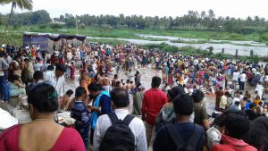
Pushkaram Sept 2017

For several hundreds of years, inhabitants of the Bangalore area dammed up the drainage channels to create “lakes” or irrigation tanks that, in addition to tapping groundwater (borewells), served as the water supply to the city. Most of the city’s lakes are between 200-300 years old. Some are estimated to be 600-700 years old. Today, the lakes no longer supply water but instead have either 1) dried up because water was diverted elsewhere, 2) became a major source of effluent drainage and therefore highly polluted and/or 3) become an aesthetically attractive urban amenity for land development around the lakes.

Ulsoor Lake Sept 2017

The main source of water comes from either ground water tanks or from water pumped up from the Kauvery River which runs east to west about 100km south of Bangalore, but more importantly, is nearly 2000 feet below the city in terms of altitude. So in addition to any natural rainfall that might replete the groundwater supply, residents must connect to the city’s water supply to make up any gaps in demand.. For residential areas built even as late as 20 years ago which were mostly dependent on groundwater, the declining supply from the borewells has forced retrofitting to access water pumped from the Kauvery. As demand for retrofits increases, residents are having to pay a fee much higher than the stated on the BSSWB website.

For more detailed analysis of the role of the lakes and the Kauvery on the water, land, and ecosystems in Bangalore, I highly recommend this wonderful “Rediscovering the Commons” interview with Dr. Balakrishnan from the Indian Institute of Human Settlements.

References

Regional Economic Competitiveness: Infrastructure (Transportation)

Most neighborhood-related issues are (seemingly) local–things like real estate development, public amenities, or public services/social development (recreation centers, schools, etc) directly impact the people who live next to or who use the facilities. Residents and elected officials most proximate physically to these kinds of issues tend to voice the greatest concern or support, and without too much contestation, deference is given to their opinions by others not in the immediate surrounding area.

However, the infrastructure systems (transportation, water, energy, etc) of metropolitan areas are, quite literally, the linkages that bind neighborhoods of the region together. Congestion in the road network anywhere will cause backups throughout the system; damming up a water source upstream may cause shortages or flooding downstream; and so on.

The question is whose voice carries the greatest sway in this context? How are “domains” of actors/entities engaged in urban governance organized to produce effective outcomes when everyone will be legitimately impacted, albeit in various ways. And, of course, what are those outcomes?

Bangalore’s Topography and History

To understand the infrastructure systems of Bangalore, it will first help to describe the topology of the region. The city is located 3000 feet above sea level on the Deccan Plateau, which is a landmass that begins to rise in the central part of India towards its highest parts (~3200 feet above see level) in the south. The triangular plateau is flanked by two mountain ranges–the Western Ghats and the Eastern Ghats.

The modern history of the city began in 1537 led by a series of Hindu and Muslim leaders until the city fell to the British (under General Cornwallis–remember him?) in 1791. The area was mostly based on an agricultural economy until a military base was established by the British and, because of the mild climate, became the chosen settlement for other Anglo- and non-Indians.

After Indian independence from the British in 1947, Bangalore slowly increased its manufacturing base. In 1985, Texas Instruments became the first “tech” company to locate in Bangalore and with the economic reforms that began in 1991, several other tech-based firms have followed. Known now as the “Silicon Valley of India” the city’s population has substantially grown from roughly 4 million in the early 1990’s to an estimated 10 million by 2021; the city is currently the 4th largest city in India.

Transportation

In many ways, until the 1990’s economic reforms, Bangalore was mostly envisioned to be a “garden city” for Indian academics and retirees. The exponential population growth over the past 20 years, therefore, is essentially occurring in a city never designed for such a large population. The most obvious result of this potential mismatch is significant road congestion. Based on data for the 2031 Master Plan, in just seven years (2008 to 2015), average journey speeds on the network have declined from 18 kmph to 11kmph. While the city authority operates over 6000 busses a day and has the first two lines of metro completed, personal vehicle use (which includes rickshaws and taxis/UBER) is now a larger share than public transit (52% vs 48%).

According to the Bangalore Mobility Indicators 2011 study that measures key performance measures on congestion, mobility and accessibility, the time delays for private vehicles is near half as much as for public transit users (See Table below).

Travel Time Index = Actual Travel Time/Ideal (free flow) Travel Time

  • Average ideal travel time for a ideal speed of 40 Kmph: 13.22 minutes
  • Average travel time along the corridors (private vehicles): 22 minutes
  • Travel time index (private vehicles): 1.69
  • Average travel time along the corridors (Public transport): 35 minutes
  • Travel time index (Public transport): 2.38

Source: (Speed and delay survey)

The stated transportation goals of the 2031 Master Plan aims to “…emphasize the pre-eminence of public transport and non-motorized modes of travel” with the goal of having 70% of all trips occurring on public transit.

Namma Metro

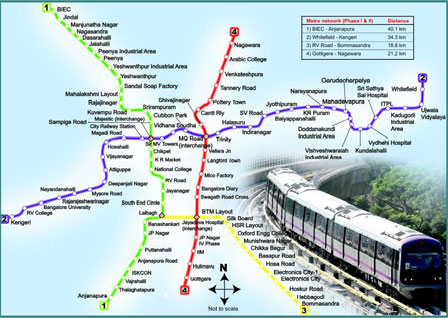
One way to address the disparity between the private and public mobility has been through the development of the Bangalore (Namma) Metro system. In operation at some level since 2011, Phase 1 of the project was just completed in 2017. There are now two fully functional lines (green and purple) of what will be a system of 4 major routes. Phase II of the network expansion, which includes activities such as budgeting, construction and land acquisition, is currently underway. In July 2017, 280,000 trips were made at the five most popular stations on the Purple Line while the top five Green Line stations saw 143,000 trips.

Namma Metro

References

The Relational Nature of Urban Governance

Just days before I left the US in July 2017, there was a convening of Baltimore folks to discuss an international research project of 8 cities (including Baltimore) exploring how collaborative governance manifests in conditions of austerity–i.e. when a jurisdiction has declining revenues and must make hard decisions about make budget cuts (Davies et al 2017). One of the findings from the team’s presentation that I found particularly interesting was that, among those in Baltimore interviewed for the project, many found it hard to know who is in charge when so many entities are involved in shaping policy in the city.

“The city has a strong mayor system… who has more influence? Is it the City? Is it a giant institution like Hopkins that has tremendous resources? …. Is it the philanthropic community? …Who’s calling the shots?”

The answer for me is essentially all of the above. The problem is figuring out how to navigate this reality to actually produce policy outcomes. Part of the research on urban collaborative governance I will be conducting in Bangalore is, of course, also of interest (and applicable) to the Baltimore context. So while the actors identified in these blog posts are from a contemporary Indian city, I find the concepts and models will resonant with anyone working on urban issues around the world.

So what is governance? Healey (citation?) describes governance as “…not a homogeneous agent, but a morass of complex networks and arenas within which power dynamics are expressed and deployed.” While this is a very accurate description of how urban areas function from experience, this can seem like a debilitating way of thinking about governance (how does one make sense of a ‘morass’ after all!). How can we move policy priorities in such complex urban arenas, and who, if anyone, is in charge?

Pieterse (2008) offers a conceptual model of the “domains” of actors/entities who are engaged in urban governance. In urban areas, these domains are in a continuous state of interaction, and how they relate to each other helps explain which domain may be more powerful, and thereby determine a particular outcome, at a given time. I find this conceptual model helpful for two main reasons: 1) rather than simply categorizing any particular entity by their pubic or non-public status, in this model any entity can be (and often are) in multiple domains simultaneously and 2) the messiness of governance comes from the multiple permutations of interactions that can and do happen in urban areas. I can think of examples in Baltimore when the voice or “power” of each one of the domains moved a project or policy forward.

The 5 domains of political engagement, and the Bangalore examples that I will be engaging with, are listed below (I hope to have a bigger list over time–and possibly revise which domain I have them categorized in).

  1. Representative Politics: The first domain consists of the formal political system, which is not only the elected officials themselves, but also the political parties that might have helped put them into power. The electoral participants themselves are, therefore, also a part of this domain which includes business interests that rely on public investments and therefore seek to influence the actors in this domain. The representative politics can play an “enabling” function that sets the climate for the other domains to participate in urban governance. Examples in Bangalore include:
    • Bruhat Bangalore Mahanagara Palike is the administrative body for the Bangalore region http://bbmp.gov.in/en/web/guest/home
    • Bangalore Development Authority
      The Bangalore Development Authority is the planning and development Agency for the Bangalore Metropolitan Area. http://www.bdabangalore.org/townplanning.html
  2. Neo-Corpororatist Stakeholder Forums: This domain refers to the formal, often regulatory forums that exist in cities to help strategize on the approach that urban policies form. This includes such forums as commissions, task forces and/or mandated participatory processes that bring together multi-sector stakeholders to set forth typically public or open strategic visions. Given mostly symmetrical levels of capacity across all actors, these forums can provide safe spaces for contestation and debate within urban areas. Examples in Bangalore include:
    • BBMP Restructuring http://www.bbmprestructuring.org/wp/
    • Bangalore Apartments Federation “formed in 2014 to represent and protect the interests of Apartments & Resident Welfare Associations across Bangalore”
  3. Direct Action/Social Movements: This domain includes the formal and informal collective action often by disadvantaged or social justice-minded groups focused on issues that shape the quality of life in urban areas. Direct action is meant to disturb the status quo and often presents itself through protesting, campaigning or some form of non-violent defiance, but have a clear philosophy or agenda that aims to address the issues raised by the impacted constituencies. “The challenge [for entities in the first two domains] is to foster a political culture that is embracing of social mobilization politics along with institutionally defined pressure-valves to absorb and channel the energy that is unleashed by direct action.” Examples in Bangalore include:
    • Citizens for Bengaluru “Citizens for Bengaluru (CfB) is a voluntary movement of, by, and for the people of Bengaluru.   The movement is focused on improving the quality of life, for all, in the city.” http://citizensforbengaluru.in/index.php/about-us/
    • Namma Bengaluru Foundation “an organization working towards making Bengaluru a model city, be it in terms of well planned infrastructure, well laid out neighborhood community models, or its people-driven governance measures” http://namma-bengaluru.org/index.php
  4. Grassroots/Community-Based Development Practice: This domain refers to the everyday practices and continuous operations of grassroots and other organizations that are involved in community/neighborhood issues. These practices interact most clearly with the other domains around development (physical and social) that occur in local areas. The most important aspect of the entities in this domain, which distinguishes it from social movements, is that they are involved in the actual implementation of urban policies which generally occurs over a medium- or long-term. Being engaged in how development unfolds builds the capacity of actors in this domain to really understand how the local democracy functions (transparency, accountability, inclusivity, etc); this experiential learning is at the root of democratic citizenship. Examples in Bangalore include:
  5. Discursive Politics/Media: Pieterse calls this domain the most “under-studied” among the five in the model. However, he raises this domain to the same level as the rest because we are surrounded by discourse everyday, and how we absorb the media or other expert knowledge shapes our and actors in the other domains views on larger systemic issues. He writes that “…[P]olitical potency of discourses can form the identity of the city and the policy imperatives that flow from it”

The ultimate question, of course, lies in whether this messy, multifaceted relational governance can be effective at aligning visions at multiple scales (metropolitan vs. local) towards common goals. Rosan (2016) offers some criteria about how to measure broad alignment (in her case how well do local areas in the US align with metropolitan goals) which I am adapting a bit to address Pieterse’s relational model:

  • localities will adopt regional plans [or visa versa in the case of strong regional authority–regional plans will incorporate local concerns]
  • the language used to talk about policy will match at different spatial levels [and across the political domains]
  • officials at different spatial levels will see the different scales as relevant to their work
  • elected officials and planners will attend meetings at different spatial levels [and across the political domains]
  • local communities [and stakeholders from the political domains] will work together to address common issues

The combination of Pieterse’s governance domains and Rosan’s effectiveness measures serve as the basis of the set of structured interview questions that I will ask the identified actors in Bangalore. Wish me luck!

Citations

Davies, J.S. et al (2017) ‘Collaborative Governance Under Austerity: An Eight-case comparative study’ Mongraph available at http://www.dmu.ac.uk/research/research-faculties-and-institutes/business-and-law/centre-for-urban-research-on-austerity/collaborative-governance-under-austerity-an-eight-case-comparative-study.aspx

Healey, P. (2002) ‘On Creating the ‘City’ as a Collective Resource’, Urban Studies, Vol. 39, No. 10: 1777-1792.

Pieterse, E. A. 2008. City futures: confronting the crisis of urban development. London: Zed Books. http://site.ebrary.com/id/10264168. A prior working paper is available online at the Princeton Institute for International and Regional Studies https://www.princeton.edu/~piirs/projects/Democracy&Development/papers/Pieterse,%20Relational%20Urban%20Politics.pdf

Rosan , C. (2016) Governing the Fragmented Metropolis: Planning for Regional Sustainability. Philadephia: University of Pennsylvania Press.

Assessing Economic Competitiveness through Infrastructure, Innovation and Inclusivity: Outcomes of Regional Governance in Bangalore, India

I am so honored and excited to embark on a Fulbright-Nehru Fellowship over the next 4 months. Thanks to the Indian Institute of Management in Bangalore Center for Public Policy for serving as my host institution!

What’s the Project Thesis?

The world’s metropolitan regions are increasingly functioning as the primary economic unit for growth and productivity globally. However, unlike nation states, the spatial boundaries of metro areas are more fluid, and many megacities are continuously expanding their spheres of influence. In many parts of the world, urban areas are evolving into sprawling megaregions which raises concerns that regional equity–in terms of income inequality or citizen political enfranchisement–may not be adequately addressed as metro areas continue to shift outward. In order to continue to remain globally competitive, research is showing that metro areas need to focus on establishing 21st century regional governance structures that ensure three key factors: adequate infrastructure to and from growing areas, a culture of innovation for businesses and new ideas, and social inclusivity.

On the first point of infrastructure, not only is the scale of the resources regional by nature (movement of goods and workers) but also issues around transportation, water and environment are more likely to find common purpose among constituents at a megaregional level. For the second point of innovation, both public sector and the private sector technology-led innovations contribute to a region’s economic competitive edge as jobs and investments “accrue” in places that signal support for adaptation and change (Tomer & Puentes 2014). Finally, as megaregions continue to grow, attention to civic inclusivity and equal opportunity for businesses and residents fosters economic competitiveness by reducing disparities and improving overall quality of life.

While these might be the aims of megaregions for economic growth, regional governance structures may not be equipped to define and support this vision. In the US, for example, there are many variations of regional governance yet very few examples of strong, institutional regional authority. With a long history of local home rule, particularly with respect to land use controls, small municipalities in the US have a lot of power to site or not site various land uses within their jurisdictions; environmentally noxious uses often locate in jurisdictions with the least resources resulting in an unequable distribution among vulnerable populations. The devolved nature of power also makes regional decision-making challenging. Even if critical issues are megaregional in scale, the policy decisions, particularly with respect to funding, are done through local, state, and federal intergovernmental relations. Starting in the 1990’s, transportation funding began to be regionalized to metropolitan planning organizations to bring greater congruence between land use patterns and infrastructure investments across jurisdictions. Many policy makers have advocated for stronger regional governmental authority, through regional elected governments such as in Portland, Oregon (Orfield 1998).

More recent research has shown that the form of government is not as critical as the presence of interconnected networks of metropolitan leaders – mayors, business and labor leaders, educators, and philanthropists—who steer city policies and investments (Katz & Bradley 2013). In regions where a broad range of representatives from the public and private sector play a lead role forming these networks, civic actors from multiple sectors of the economy de facto participate in regional governance and ultimately set the context for greater innovation.  The impetus for innovation within metropolitan areas comes from growing demand for more effective service delivery in the face of limited and declining public sector resources available to address difficult problems (Sorenson & Torfing 2012). Collaborative innovation among multi-sector actors within a metro area is a process that moves from interaction to collaboration to innovation. In order to progress through the stages of that process, data sharing as a management strategy can help establish inclusive knowledge among potential collaborators (Iyer 2015). Data that measures effectiveness of city services and improvement in quality of life can promote citizen participation by demonstrating how use of data can establish a democratic space for engagement.

For some of the methods I’ll be using to help answer some of these questions, visit this google doc (subject to ongoing updates!)

Why Bangalore?

Metropolitan regions have become the geographic scale and economic unit in the global competitive marketplace. In often separate sectors of metropolitan areas, advocates for civic and social equity have sought to build new forms of political authority or cooperation at a regional scale to better address issues of inequality. In many ways, multi-sector actors who might appear to be working at cross-purposes are in agreement with respect to the scale at addressing key regional issues. For seemingly unlikely allies within a region, while the structure of government (more regional vs. more decentralized) can have important impacts on both competitiveness as well as equity, it’s the results or outcomes of regional governance that ultimately determine the effectiveness of any approach. For example, infrastructure improvements often involve access to resources outside the region; the region’s ability to leverage resources (power and/or funding) from national and global entities can be assessed through strong intergovernmental relations (i.e. how federal dollars and governing laws flow). The region’s capacity to innovate can be measured by the breadth and interconnectedness of regional networks whose multi-sector actors work together to move forward urban policies and priorities. Finally, inclusivity throughout the region can show both spatial and socioeconomic disparities; community based indicators help multi-sector actors monitor if policies are reducing disparties. This research contributes to the growing body of work around megacities, smart cities, and/or sustainable cities that helps identify the key outcomes of political and planning processes across all metropolitan areas.

The Bangalore metro region presents a current case-study of the relationship between regional economic competitiveness and political restructuring. Since the 1990’s, the region has grown economically through advancements in the technology sector in particular; it is ranked 16th among Asian cities in terms of competitiveness (EIU 2012). In 2014, the Government of Karnataka commissioned a task force/expert committee to provide recommendations for the restructuring of the current Bruhat Bengaluru Mahanagar Palike (BBMP-Bangalore Municipal Corporation) to better manage the needs of and services to the rapidly growing metropolitan area. The expert committee delivered recommendations on July 13, 2015 to maintain an overall regional structure through a Greater Bangalore Authority, but devolve administrative responsibilities through municipal corporations and foster greater citizen engagement via many smaller wards. The stated purpose of the restructuring is to increase responsiveness to citizen concerns, promote accountability and transparency both fiscally and with respect to service provision, and build capacity for local planning practices for coordination across the public sector. Although not stated specifically, economic competitiveness is mentioned roughly as a concern raised that the restructuring should not interfere with the global “Bengaluru Brand”.

Bibliography

BBMP Restructuring Committee (2015), “Bengaluru: Way Forward” Government of Karnataka http://www.bbmprestructuring.org/wp/the-final-bbmp-restructuring-report/

Iyer, Seema D. (2015) “Barriers to Data Sharing for Inclusive Knowledge Management: Why WatershedStat in Baltimore City Failed” in Innovations in the Public and Nonprofit Sectors: A Public Solutions Handbook, Patria de Lancer Julnes & Ed Gibson, eds., M.E. Sharpe Press. Pp. 91-109.

Katz, B., & Bradley, J. (2013). The Metropolitan Revolution. [electronic resource] : How Cities and Metros Are Fixing Our Broken Politics and Fragile Economy. Washington, D.C. : Brookings Institution Press, 2013.

Orfield, M. (1998). Metropolitics: A regional agenda for community and stability. Washington, D.C. : Brookings Institution Press ; Cambridge, Mass. : Lincoln Institute of Land Policy, 1998.

Tomer, Adie & Robert Puentes (2014), “Getting Smarter About Smart Cities,” Brookings Institution Research Brief.  Accessed online April 2016 http://www.brookings.edu/research/papers/2014/04/23-smart-cities-puentes-tomer

Sorenson, Eva & Jacob Torfing (2012), “Collaborative Innovation in the Public Sector” in The Innovation Journal: The Public Sector Innovation Journal, Vol 17, no 1, pp. 1-14.