Hi! I’m Pete Ramsey, one of the Reference and Instruction librarians at Langsdale Library, and I also teach the Information Literacy (IDIS 110) course in first-year student learning communities.
In my course, I like to include a segment where students demonstrate an interesting web site or web-based tool that relates to information literacy. I saw some interesting (and occasionally controversial) demos this semester, including these two:
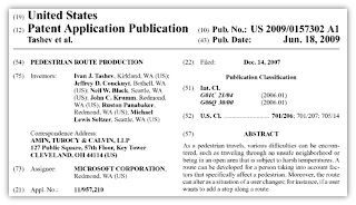
 Microsoft’s “Pedestrian Route Production” Mobile App
Sometimes called the “Avoid Ghetto” app, this tool recommends walking directions based on weather, crime statistics, and population demographics. The app has received a lot of attention, due in large part to protests from civil liberties organizations, which claim that it highlights social discrimination and drives away potential business from the neighborhoods that need the most attention.
 The Baltimore Sun’s Homicide Mapping Website
This site, not-so-affectionately called the “Baltimore Death Map,” shows a map of Baltimore homicide victims as far back as 2007. Clicking on a pin shows the victim’s name, age, gender, race, cause of death, and a link to any Sun articles about the homicide. A bit disturbing, I suppose, but an intriguing way to reveal the darker side of living and dying in Baltimore.
About the Open Data Movement
Both of the above tools demonstrate intelligent use of information made available by “open data” practices. The idea behind open data is to provide certain statistics and data freely for people to use without worrying about violating someone’s intellectual property restrictions. A lot of governments and cities are providing this kind of data, and app and web developers are making really interesting reports and tools.
Baltimore’s Open Data
Baltimore city has two top-notch open data projects. There’s OpenBaltimore with its goal of providing “access to City data in an effort that supports government transparency, openness and innovative uses that will help improve the lives of Baltimore residents, visitors and businesses” (Hint: recently got a parking citation? Look it up here). There’s also the VERY nice CityView map, which offers various base maps of the city and numerous data layers (for example, you can see a sobering map of the many vacant buildings).

Pretty interesting. And good to know about.